Amros Corporation’s breakthrough ShaleVision™ technology identifies the highest producing zones in shale plays using only open-hole log data, providing operators with optimum locations and trajectories for horizontal wells to maximize profitability and avoid drilling low-productive wells, reducing development cost and environmental impact. It provides also key information to optimize well spacing.
Within 24 hours of receiving standard open-hole log data for a well, Amros develops a Production Profile, an Amros innovation that accurately predicts production along the entire well in barrels per day per 100 feet. Log data can be limited to gamma ray, resistivity, neutron and density porosity. When combined with data from surrounding vertical wells, ShaleVision™ identifies the best formations and optimum trajectories for horizontal wells along with estimates of production. Deliverables include:
- Production Profiles with recommended fracking stages and brittleness
- Locations of the best formations and zones
- Production maps for the best formations
- Recommended trajectories for horizontal wells with initial production estimates

This chart demonstrates how ShaleVisionTM was used to identify entry points for horizontal wells based on log data for a vertical well. It shows a segment of Production Profile (brown line), along with brittleness (black) and water saturation (blue), with the best entry zone for a horizontal well highlighted.
The Initial Production (IP) estimate for the horizontal well (850 Bbl./day) was calculated assuming a 7,000 ft. lateral and was based on a correlation with the production profile of a neighboring vertical well. This is one of four high potential horizontal wells identified by the Production Profile for the entire well.
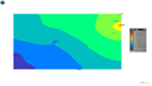
Based on Production Profiles from vertical wells, ShaleVision™ identifies the best zones and provides production maps and trajectories for horizontal wells for these zones with a color scale that indicates production in Bbl./day per 100 ft. The production map show the production potential for Wolfcamp A
in an underexplored area of about 200,000 acres. The maps also indicate the location of vertical wells that were used to generate the maps. The map shows the increasing trend for production from NE to SW.
“Amros identified the best formation and built production maps for these formations. In addition the trajectories and initial production for horizontal wells were identified. We can now identify the areas where we can drill up to 6 high producing horizontal wells in the same location. The service companies that worked with us before Amros could not produce these definitive results”.
Danny S. Davis, President of Escopeta Oil & Gas Corporation